Hurricane Dora Hit St. Augustine With 110 MPH Winds in 1964: Northeast Florida's Benchmark Storm
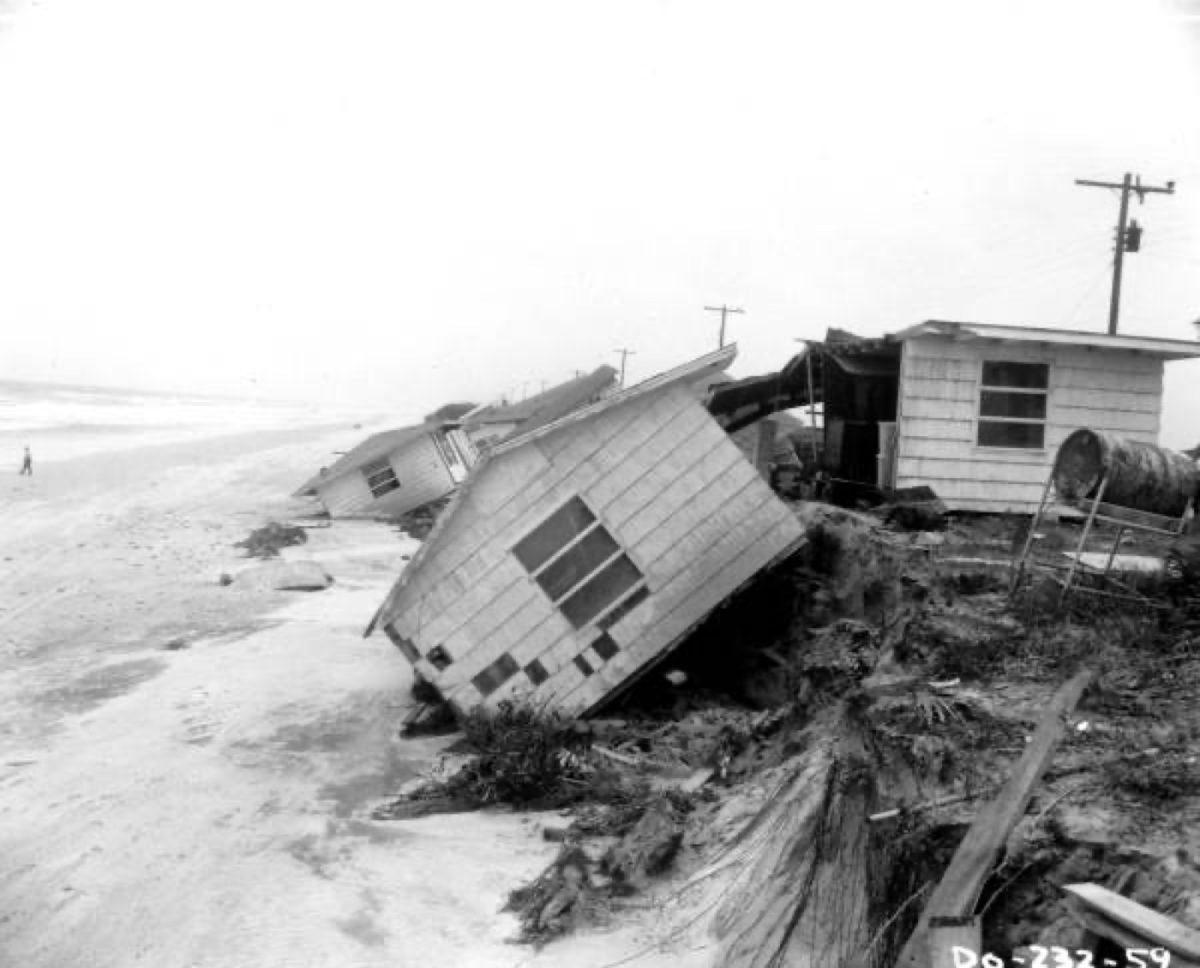
Damage in Jacksonville after Hurricane Dora in 1964. Photo: Florida Memory / Wikimedia Commons (no known restrictions)
Jacksonville, Fla. - Hurricane Dora came ashore about 6 miles north of St. Augustine at 12:20 a.m. on Sept. 10, 1964, according to the National Weather Service. It was the first hurricane to make landfall in Northeast Florida in the 20th century.
NOAA's official hurricane database puts Dora's sustained winds at about 110 mph at landfall, a strong Category 2. The Weather Service estimates peak winds in St. Augustine reached 125 mph. Tides ran 5 to 8 feet or more above normal along the coast, and about 12 feet across Anastasia Island.
Dora by the numbers
| Measure | Figure | Source |
|---|---|---|
| Landfall | 12:20 a.m. Sept. 10, 1964, about 6 miles north of St. Augustine (radar) | National Weather Service |
| Winds at landfall | 95 knots (about 110 mph), Category 2 | NOAA HURDAT2 |
| Pressure near landfall | 966 millibars | NOAA HURDAT2 |
| Peak strength at sea | 115 knots (about 130 mph), Category 4, on Sept. 6 | NOAA HURDAT2 |
| Estimated peak wind in St. Augustine | 125 mph | National Weather Service |
| Tides | 5 to 8 feet or more above normal; about 12 feet on Anastasia Island | National Weather Service |
| Wettest spot | 23.73 inches at Mayo | NOAA Weather Prediction Center |
| Damage | $200 million to $230 million in 1964 dollars | National Weather Service |
From the coast of Africa to St. Augustine
Dora started as a tropical depression near the Cape Verde Islands on Aug. 28, 1964, NOAA's records show. It became a tropical storm Aug. 31 and a hurricane Sept. 2.
The storm peaked on Sept. 6, more than 500 miles north of Puerto Rico, at 130 mph with a central pressure of 942 millibars. It then turned west toward Florida and weakened slightly, but it stayed a hurricane all the way to the coast.
Dora slowed as it neared North Florida, the Weather Prediction Center says. That gave people time to evacuate, though few residents had any experience with hurricane evacuations. NOAA calls Dora the first hurricane to hit Northeast Florida in at least 79 years.
The storm's path after landfall
| Date (Eastern time) | Where Dora was | Strength |
|---|---|---|
| Sept. 10, 12:20 a.m. | Landfall north of St. Augustine | Category 2, about 110 mph |
| Sept. 10, 2 p.m. | Moving west across North Florida | Tropical storm, about 65 mph |
| Sept. 11 | Near Tallahassee and the Big Bend | Tropical storm |
| Sept. 12 | Turning north and east across south Georgia | Tropical storm |
| Sept. 13 | Off the Carolinas | No longer tropical |
Times are converted from the six-hour positions in NOAA's HURDAT2 database. The landfall time comes from Weather Service radar.
Damage on the coast
The Weather Service says many coastal roads were damaged or destroyed, and more than 40 homes along the coast were lost. Its count runs from 40 to 43, depending on the report.
Because Dora slowed as it reached the coast, high tides and pounding surf hit the beaches for hours.
Rain and river flooding inland
Dora's rain did as much damage inland as its winds did on the coast. More than 10 inches of rain fell over about 10,000 square miles, the Weather Service says.
| Place | Rain |
|---|---|
| Mayo | 23.73 inches |
| Live Oak | 18.62 inches |
The heaviest rain fell Sept. 11 and 12, the Weather Prediction Center says, as the slow-moving storm turned and doubled back east.
The rain caused the flood of record on the Santa Fe River at Fort White. It also set the record for the St. Marys River basin, which held until Tropical Storm Debby in 2012. The Weather Service reports one drowning, in Live Oak.
The Beatles played anyway
The Beatles' concert at the Gator Bowl went ahead on Sept. 11, 1964, the day after landfall. Action News Jax reports the band insisted on playing to an integrated audience at the then-segregated stadium.
Why Dora still matters
More than 60 years later, Dora is still the benchmark storm for Jacksonville and St. Augustine. Its damage had several causes: storm surge on the beaches, a slow-moving center and days of inland flooding. Those are the same hazards forecasters warn about today.
Know your evacuation zone and check the Jax Times hurricane center when a storm is coming.
How we did this
Jax Times rebuilt this story on Oct. 24, 2026, from three federal sources:
- Track and intensity: NOAA's HURDAT2 Atlantic hurricane database, the official record of every storm's six-hour position, winds and pressure.
- Landfall, winds, tides, damage and river flooding: the National Weather Service's account of Hurricane Dora in its Florida flood history.
- Rainfall: the NOAA Weather Prediction Center's Dora rainfall summary.
Knots are converted to mph and rounded. Times are converted from UTC to Eastern.
Earlier versions of this story relied on Wikipedia. We removed figures we couldn't confirm in these records, including power-outage counts, county-by-county home damage and national death tolls.
Sources: NOAA HURDAT2 hurricane database; National Weather Service, Florida flood history; NOAA Weather Prediction Center, Dora rainfall; Action News Jax
News organizations may republish this story with credit. See our guidelines.
Know someone who'd want to read this? Email it to a friend.
Own a Jacksonville business? Introductory ad rates from $125/month. See ad optionsPlan your weekend with Jax Times
Get This Weekend in Jacksonville every Thursday: the best local events, free things to do and family fun, plus each evening's local news. Free, and you can unsubscribe anytime.
Most read this week
- Florida's 3 Constitutional Amendments on the Nov. 3 Ballot, Explained in Plain English
- Florida Is Holding $3 Billion in Unclaimed Money. Here's How Jacksonville and St. Augustine Residents Can Search for Free
- Fire Destroys Golf Carts of St. Augustine Building on U.S. 1: What We Know, What Happens Next and 9 Golf Cart Battery Safety Rules
- St. Augustine Artist Dara Dodson Paints 'A Land Remembered,' With Shows at the Karpeles Museum and the St. Augustine Art Association
- St. Johns Is Florida's Fastest-Growing County, Adding 36 People a Day, as Northeast Florida Passes 2 Million
More stories
 Local St. Johns River by the Numbers: 310 Miles, a Northward Flow and Less Than 30 Feet of Drop
 Local Phase III Water Restrictions: Your 1 Watering Day by Address, the 10 Hours You Can't Water and What's Exempt
 Local Stay Out of the Ocean This Weekend: 7- to 11-Foot Waves and Dangerous Rip Currents at Northeast Florida Beaches
 Local Coastal Flood Warning for Jacksonville: Water Peaks Sunday and Monday Mornings in 5 Flood-Prone Areas
Comments
Be respectful. No personal attacks, hate speech, spam or anyone's private information. Every comment is reviewed before it appears. Comment rules
No comments yet. Be the first to share your thoughts.