St. Johns County Under Coastal Flood Warning Through Monday: What Residents Need to Know
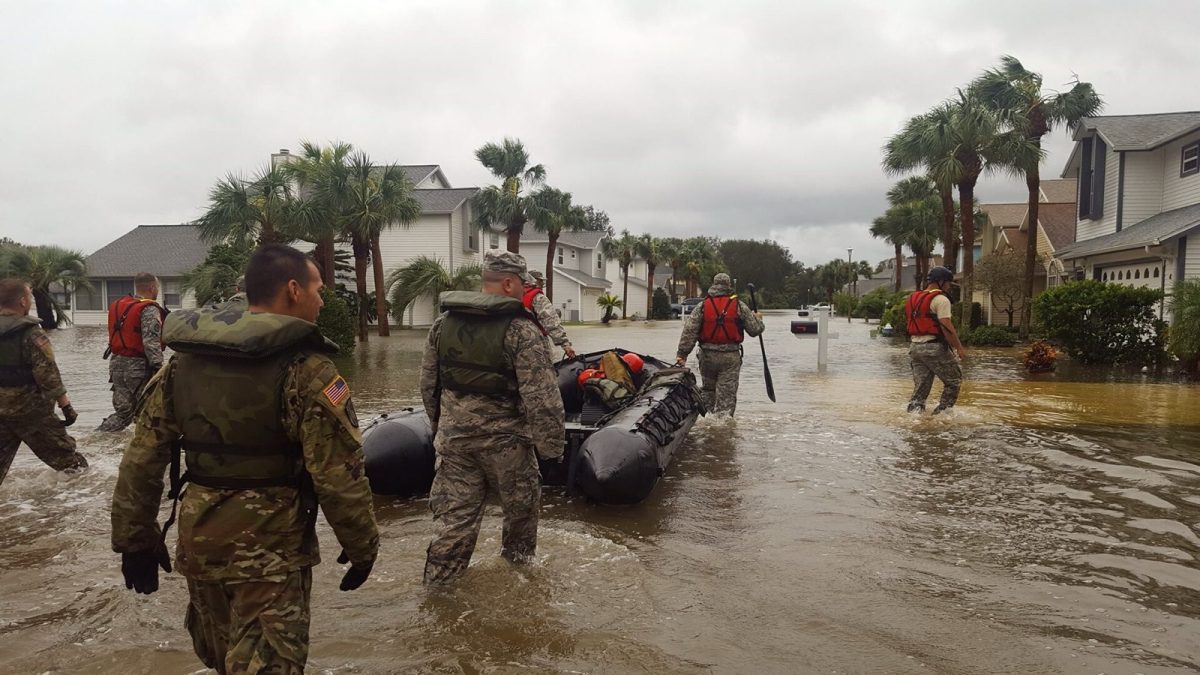
Florida National Guard members on a search and rescue mission in St. Augustine after Hurricane Matthew, Oct. 7, 2016 (file photo). Photo: The National Guard / Wikimedia Commons (CC BY 2.0)
ST. AUGUSTINE, Fla. - St. Johns County is under coastal flood warnings through Monday evening, Oct. 26, as strong northeast winds and unusually high tides threaten flooding along the Atlantic coast and St. Johns River basin. The National Weather Service expects significant coastal flooding, with some roads potentially closed and low-lying properties inundated. Residents in St. Augustine, St. Augustine Beach, Vilano Beach, Ponte Vedra and western St. Johns County should prepare for hazardous conditions throughout the weekend.
The coastal warning begins at 5 p.m. Saturday, Oct. 24, and continues until 8 p.m. Monday, replacing a coastal flood advisory that covers minor flooding earlier Saturday. A separate flood warning for the St. Johns River basin, including western St. Johns County, began at 5 a.m. Saturday and also continues until Monday evening. The National Weather Service warns that homes, businesses and some critical infrastructure in low-lying areas could experience flooding.
St. Johns County Emergency Management says strong northeast winds combined with the highest astronomical tides of the year could produce moderate to locally major tidal flooding from Saturday through Monday. The greatest flooding risk will occur around high tide along the Atlantic coast, Intracoastal Waterway and St. Johns River basin. Residents also face wind gusts, dangerous surf and a high risk of rip currents, making this a weekend to monitor local warnings and avoid unnecessary exposure to hazardous conditions.
Weekend Weather Timeline: Saturday Through Monday
Several weather alerts overlap this weekend, but they do not all begin and end at the same time. Coastal flooding is the longest-lasting concern, while the wind advisory covers a shorter period. Dangerous surf and rip currents are expected to remain a concern through Monday.
| Day | Alerts and expected conditions |
|---|---|
| Saturday, Oct. 24 | River basin flood warning begins at 5 a.m. High surf advisory starts at 8 a.m. Wind advisory begins at noon. Coastal flood warning starts at 5 p.m., replacing the earlier advisory. |
| Sunday, Oct. 25 | Coastal and river basin flood warnings continue. County officials warn of possible wind gusts of 35 to 45 mph Sunday into Monday. High surf and rip current risks continue. |
| Monday, Oct. 26 | Coastal flood warnings and high surf advisory remain in effect until 8 p.m. High rip current risk continues through Monday evening. |
The National Weather Service issued its coastal hazard message at 7:33 p.m. Friday and its wind advisory at 7:01 p.m. Friday. Forecast conditions may create different hazards depending on whether residents live along the Atlantic beaches, the Intracoastal Waterway or the river basin. Residents should check updated forecasts rather than assume conditions will remain the same throughout the weekend.
Coastal Flooding: St. Augustine, Vilano Beach and the River Side
The coastal flood warning covers Northeast Coastal St. Johns and Southeast Coastal St. Johns, including areas along the county's Atlantic shoreline. The National Weather Service expects significant coastal flooding and warns that numerous roads may close as water reaches vulnerable locations. Low-lying homes, businesses and some critical infrastructure could be inundated, while shoreline erosion may also occur.
Flooding is not limited to beachfront communities such as St. Augustine Beach, Vilano Beach and Ponte Vedra. St. Johns County Emergency Management specifically identifies tidal waterways, the Intracoastal Waterway and the St. Johns River basin as areas of concern. Western St. Johns County is included in the separate river basin coastal flood warning, which remains in effect through 8 p.m. Monday.
The county says the highest flooding risk will occur around high tide, when strong northeast winds combine with unusually high astronomical tides. Residents in low-lying areas should take precautions to protect their property before water begins rising. The National Weather Service also advises drivers never to travel around barricades or through water when the depth is unknown.
Strong Winds Could Affect Driving and Power
A wind advisory covers both coastal and inland sections of St. Johns County from noon Saturday until 1 a.m. Sunday. The National Weather Service forecasts northeast winds of 15 to 25 mph, with gusts reaching 40 mph during the advisory period. These conditions could bring down tree limbs, cause a few power outages and make driving difficult for high-profile vehicles.
St. Johns County Emergency Management also warns that gusts could reach 35 to 45 mph Sunday into Monday. Residents should secure loose outdoor belongings, including holiday decorations, lawn ornaments, patio furniture and trash cans. The county specifically included holiday decorations in its safety recommendations, an important precaution during the Halloween season.
Dangerous Surf and Rip Currents Through Monday
A high surf advisory covers the St. Johns County coastline from 8 a.m. Saturday until 8 p.m. Monday. The National Weather Service expects large breaking waves of 7 to 11 feet, along with dangerous swimming and surfing conditions. Localized beach erosion is also possible, and the high rip current risk continues through Monday evening.
St. Johns County Emergency Management describes the surf as life-threatening and urges boaters to avoid offshore gale conditions and postpone trips. Beachgoers should stay away from seawalls and jetties when large waves are breaking. Even people who do not plan to enter the water should avoid exposing themselves to dangerous surf conditions.
The National Weather Service recommends swimming near a lifeguard and knowing how to respond if caught in a rip current. Anyone caught in one should relax and float rather than try to swim directly against the current. Swimming parallel to shore can help someone escape, while facing shore and calling or waving for help is another recommended response.
Areas That Flooded Earlier This Month
Several St. Augustine locations experienced flooding during the king tides of Oct. 9 through Oct. 13, according to an Oct. 9 report from News4JAX. Those areas included historic downtown St. Augustine, Oglethorpe Boulevard in Davis Shores and the Maria Sanchez Lake area. These are locations that experienced flooding earlier this month, not locations where flooding has been confirmed during the current weekend.
News4JAX also reported that several vehicles stalled on flooded roads during the preceding week. City and county crews monitored roads, cleared drains and posted warning signs as flooding concerns developed. Those earlier problems show why residents should pay attention to water on streets even when a road has not been officially closed.
Jessica Beach, St. Augustine's chief resilience officer, compared the city's drainage system to a funnel that can overflow when water arrives too quickly. News4JAX also reported that a seawall protects Davis Shores, while a seawall at Maria Sanchez Lake remains in design with a planned pump at its south end. Neither the earlier flooding nor those infrastructure details establish that the same streets will flood this weekend.
What We Could Not Confirm: Sandbags and Road Closures
As of Saturday morning, Oct. 24, Jax Times could not confirm any county or city announcement offering sandbag distribution for this weather event. We also could not confirm announced closures of A1A, roads in Vilano Beach, the Bridge of Lions or other local roadways. That does not mean flooding or closures will not occur as conditions change.
The National Weather Service warns that numerous roads may close because of significant coastal flooding. Drivers should treat water-covered roads cautiously even when they have not seen an official closure announcement. Residents should follow the St. Johns County Emergency Management Facebook page and sign up for Alert St. Johns to receive changing emergency information.
Eight Steps Residents Can Take This Weekend
1. Move vehicles away from low spots. Avoid parking overnight in places that commonly collect water during tidal flooding. Moving a vehicle to higher ground, such as an available parking garage, is a general safety precaution. Saltwater can damage vehicles, so preventing exposure is preferable to dealing with flood damage.
2. Never drive through floodwater. The National Weather Service advises drivers not to enter water of unknown depth or travel around barricades. Its Turn Around Don't Drown guidance warns that a foot of water can float many cars. Find another route rather than attempt to cross a flooded road.
3. Stay out of moving floodwater. Just six inches of moving water can knock a person down, according to general National Weather Service safety guidance. Flooded streets and low-lying areas can create dangerous conditions for pedestrians as well as drivers. Avoid walking through moving water, even when it appears shallow.
4. Secure outdoor belongings. Bring in or secure patio furniture, trash cans, lawn ornaments and holiday decorations before stronger winds arrive. The county specifically recommends these precautions ahead of the weekend weather. Loose items can become a problem when gusts reach the levels forecast by weather officials.
5. Prepare flood-prone property. Residents near the coast, Intracoastal Waterway or tidal sections of the St. Johns River should pay particular attention to their surroundings. The National Weather Service recommends taking necessary actions to protect properties vulnerable to flooding. Do not assume an area is safe simply because it is away from the Atlantic beachfront.
6. Stay away from dangerous surf. Breaking waves of 7 to 11 feet are expected along the coast through Monday evening. Avoid walking on seawalls and jetties during periods of high surf. The National Weather Service warns that swimming and surfing conditions will be dangerous.
7. Postpone hazardous boating trips. St. Johns County Emergency Management advises boaters to avoid offshore gale conditions and postpone trips. The coastal weather hazards are expected to continue into Monday. Boaters should consult current marine weather information before making plans.
8. Monitor warnings throughout the weekend. Flood risks will be highest around high tide, but the warnings cover several days. Keep checking official weather updates and local emergency notifications for possible changes to road conditions and safety guidance. Do not rely solely on conditions observed earlier in the day.
Where to Get Official Weather and Emergency Alerts
Residents can follow the National Weather Service Jacksonville office at https://weather.gov/jax for weather warnings, advisories and updated forecasts. The office issued the coastal flood, high surf and wind alerts affecting St. Johns County this weekend. Its information can help residents distinguish between the risks along the Atlantic coast and those affecting the St. Johns River basin.
St. Johns County Emergency Management posts information at https://facebook.com/StJohnsEOC and provides access to Alert St. Johns emergency notifications at https://www.sjcfl.us/departments/emergency-mgmt/. Residents should use these official channels to check for new emergency announcements, including any future information about sandbags or road closures. The county's Oct. 23 safety release is available at https://www.sjcfl.us/sjc-residents-weekend-weather-safety-precautions-oct-2026/.
How We Did This
Jax Times prepared this guide using National Weather Service Jacksonville coastal hazard and wind advisories issued Friday, Oct. 23, 2026. We also used the Oct. 23 St. Johns County Emergency Management safety release and an Oct. 9 News4JAX report about earlier flooding in St. Augustine. Information about previously flooded streets is historical context and should not be interpreted as confirmation of flooding or road closures this weekend.
Sources: National Weather Service Jacksonville; St. Johns County Emergency Management (Oct. 23, 2026); News4JAX (Oct. 9, 2026)

News organizations may republish this story with credit. See our guidelines.
Know someone who'd want to read this? Email it to a friend.
Own a Jacksonville business? Introductory ad rates from $125/month. See ad optionsPlan your weekend with Jax Times
Get This Weekend in Jacksonville every Thursday: the best local events, free things to do and family fun, plus each evening's local news. Free, and you can unsubscribe anytime.
Most read this week
- Florida's 3 Constitutional Amendments on the Nov. 3 Ballot, Explained in Plain English
- Florida Is Holding $3 Billion in Unclaimed Money. Here's How Jacksonville and St. Augustine Residents Can Search for Free
- Fire Destroys Golf Carts of St. Augustine Building on U.S. 1: What We Know, What Happens Next and 9 Golf Cart Battery Safety Rules
- St. Augustine Artist Dara Dodson Paints 'A Land Remembered,' With Shows at the Karpeles Museum and the St. Augustine Art Association
- Jacksonville Fair 2026 Guide: Dates, Gate Times, Ticket Prices, Free Days and Every Concert (Nov. 5-15)
More stories
 Local St. Johns River by the Numbers: 310 Miles, a Northward Flow and Less Than 30 Feet of Drop
 Local Phase III Water Restrictions: Your 1 Watering Day by Address, the 10 Hours You Can't Water and What's Exempt
 Local Stay Out of the Ocean This Weekend: 7- to 11-Foot Waves and Dangerous Rip Currents at Northeast Florida Beaches
 Local Coastal Flood Warning for Jacksonville: Water Peaks Sunday and Monday Mornings in 5 Flood-Prone Areas
Comments
Be respectful. No personal attacks, hate speech, spam or anyone's private information. Every comment is reviewed before it appears. Comment rules
No comments yet. Be the first to share your thoughts.