Northeast Florida Coastal Flood Warning Extended to Wednesday: High Tide Times for Mayport, Fernandina and St. Augustine
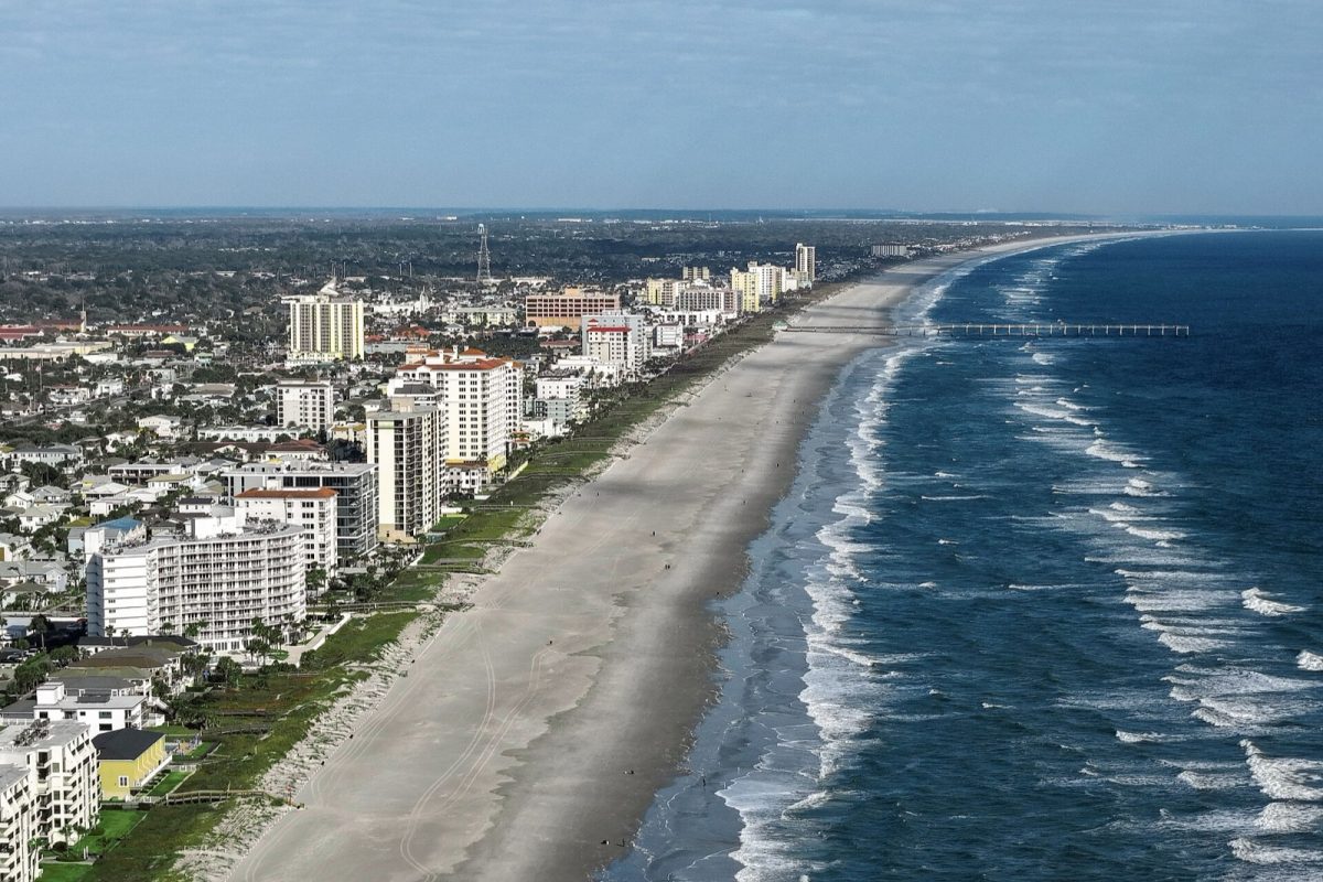
Jacksonville Beach from the air (file photo). The coastal flood warning now runs until 5 a.m. Wednesday, Oct. 28. Photo: Quintin Soloviev / Wikimedia Commons (CC BY 4.0)
JACKSONVILLE, Fla. - The National Weather Service has extended coastal flood warnings for Northeast Florida beaches and the St. Johns River basin until 5 a.m. Wednesday, Oct. 28, as significant coastal flooding remains possible around high tide. The warnings previously were scheduled to expire at 8 p.m. Monday. The extension means residents in flood-prone areas should continue watching water levels through Tuesday night and early Wednesday.
The latest Coastal Hazard Message, issued at 3:47 a.m. Sunday, Oct. 25, also keeps a High Surf Advisory in place until 2 a.m. Wednesday. Breaking waves of 8 to 10 feet are expected along Northeast Florida beaches, with a high risk of rip currents through late Tuesday night. A separate Wind Advisory remains in effect until 8 p.m. Sunday, with northeast wind gusts reaching 40 mph.
What changed Sunday morning
The biggest change is the extension of the coastal flood warnings from Monday evening to early Wednesday morning. The beach warning covers Coastal Nassau, Coastal Duval, Coastal Flagler, Northeast Coastal St. Johns and Southeast Coastal St. Johns. The National Weather Service describes the expected conditions in these areas as "significant coastal flooding around times of high tide."
The warning also extends to the St. Johns River basin, where the weather service expects moderate flooding around high tides. Areas covered include Trout River, South Central Duval, Eastern Clay, Western St. Johns, Eastern Putnam and Inland Flagler. Both the beach and river basin warnings now expire at 5 a.m. Wednesday.
Saturday's Jax Times coverage addressed flooding in Duval County, dangerous beach surf and conditions in St. Johns County. Those earlier stories reflected warnings that were scheduled to end Monday night. Sunday's update replaces that earlier expiration time with Wednesday morning.
High tide times for Mayport, Fernandina Beach and St. Augustine
NOAA tide predictions show morning high tides gradually increasing through Tuesday and Wednesday at Mayport, Fernandina Beach and St. Augustine Beach. The morning high tide is higher than the evening high tide at all three locations on Sunday, Monday and Tuesday. Based on these astronomical predictions, Monday and Tuesday morning high tides deserve particular attention while the coastal flood warnings remain in effect.
Important: The tide heights below are normal astronomical predictions measured in feet above mean lower low water. They do not include additional water pushed toward shore by the wind. Actual water levels can run higher than the listed predictions, so the numbers should not be treated as the maximum water levels expected during the coastal flood warning. All times in the table are local Eastern time.
NOAA predicted high tides
| Day | Location | Morning high tide | Evening high tide |
|---|---|---|---|
| Sun., Oct. 25 | Mayport | 8:24 a.m., 5.9 ft | 8:46 p.m., 5.3 ft |
| Sun., Oct. 25 | Fernandina Beach | 8:33 a.m., 7.4 ft | 8:56 p.m., 6.7 ft |
| Sun., Oct. 25 | St. Augustine Beach | 7:49 a.m., 6.1 ft | 8:13 p.m., 5.3 ft |
| Mon., Oct. 26 | Mayport | 9:10 a.m., 6.1 ft | 9:32 p.m., 5.3 ft |
| Mon., Oct. 26 | Fernandina Beach | 9:21 a.m., 7.7 ft | 9:43 p.m., 6.7 ft |
| Mon., Oct. 26 | St. Augustine Beach | 8:34 a.m., 6.3 ft | 8:58 p.m., 5.2 ft |
| Tue., Oct. 27 | Mayport | 9:58 a.m., 6.2 ft | 10:21 p.m., 5.2 ft |
| Tue., Oct. 27 | Fernandina Beach | 10:10 a.m., 7.8 ft | 10:33 p.m., 6.6 ft |
| Tue., Oct. 27 | St. Augustine Beach | 9:21 a.m., 6.5 ft | 9:46 p.m., 5.2 ft |
| Wed., Oct. 28 | Mayport | 10:48 a.m., 6.2 ft | Not listed |
| Wed., Oct. 28 | Fernandina Beach | 11:03 a.m., 7.8 ft | Not listed |
| Wed., Oct. 28 | St. Augustine Beach | 10:10 a.m., 6.5 ft | Not listed |
The predictions show Mayport's morning high tide rising from 5.9 feet Sunday to 6.2 feet Tuesday. Fernandina Beach rises from 7.4 feet to 7.8 feet over the same period, while St. Augustine Beach rises from 6.1 feet to 6.5 feet. Wednesday morning's predicted high tides remain at Tuesday's levels at all three locations, although the coastal flood warnings are currently scheduled to end at 5 a.m. Wednesday.
These predictions describe the normal astronomical tides, not the total water levels that may occur during the coastal flooding event. The additional water pushed in by wind can produce higher levels than the tide tables alone suggest. Residents should therefore use the predicted high tide times as a guide to when flooding deserves closer attention, rather than relying on the listed heights as a measure of the full flooding threat.
Flooding could close roads and affect property
The National Weather Service warns that numerous roads may be closed during the coastal flooding event. Low-lying property, including homes, businesses and some critical infrastructure, may be inundated. Shoreline erosion is also expected as high water and dangerous surf continue affecting coastal areas.
The impacts extend beyond beachfront locations because the St. Johns River basin remains under its own Coastal Flood Warning. While the weather service describes the beach threat as significant flooding, it describes the river basin threat as moderate flooding around high tides. Both warnings remain in effect through early Wednesday, making repeated high tide periods an ongoing concern.
Residents with flood-prone property should take steps to protect it while the warnings remain active. Drivers should never go around barricades or attempt to cross water when they do not know its depth. Road closures and flooded low-lying areas are among the specific hazards identified in the weather service warning.
Dangerous surf and rip currents through Tuesday night
A High Surf Advisory remains in effect for Northeast Florida beaches until 2 a.m. Wednesday, with large breaking waves of 8 to 10 feet. The National Weather Service also maintains a high rip current risk through late Tuesday night. These conditions create dangerous swimming and surfing conditions and may cause localized beach erosion.
The weather service advises inexperienced swimmers to stay out of the water during dangerous surf conditions. Anyone who enters the water should swim near a lifeguard and remain aware of the high rip current risk. The advisory remains active beyond Monday, so the threat is not limited to Sunday's conditions.
Anyone caught in a rip current should relax and float rather than attempt to swim directly against it. The National Weather Service advises swimming along the shoreline to escape the current. Those who need assistance should face the shore and call or wave for help.
Wind Advisory remains active through Sunday evening
A separate Wind Advisory remains in effect until 8 p.m. Sunday for coastal areas of Nassau, Duval, Flagler and St. Johns counties. The advisory also covers Northern and Southern Inland St. Johns and Inland Flagler. Northeast winds of 15 to 25 mph are expected, with gusts reaching up to 40 mph.
The National Weather Service warns that the winds could blow down tree limbs and cause a few power outages. The wind advisory has an earlier expiration time than the coastal flooding and high surf alerts. Residents should distinguish Sunday's wind deadline from the warnings that continue through Tuesday night and early Wednesday.
Southeast Georgia beaches also under warning
The coastal flooding threat also affects Southeast Georgia beaches, including Glynn and Camden counties. A Coastal Flood Warning for Coastal Glynn and Coastal Camden remains in effect until 11 a.m. Tuesday, with surf of 5 to 7 feet. These counties are also covered by the Wind Advisory through 8 p.m. Sunday.
Timeline: When the warnings expire
The active alerts have different ending times, with the Wind Advisory ending first and the coastal flood warnings remaining in place longest. The Northeast Florida High Surf Advisory extends into early Wednesday, while the high rip current risk continues through late Tuesday night. The following timeline summarizes the deadlines listed in the latest weather service messages.
| Date and time | Alert or event |
|---|---|
| Sunday, Oct. 25, 8 p.m. | Wind Advisory ends |
| Monday, Oct. 26, 8 p.m. | Previous coastal flood warning expiration, now superseded |
| Tuesday, Oct. 27, 11 a.m. | Southeast Georgia Coastal Flood Warning ends |
| Late Tuesday night | High rip current risk continues through this period |
| Wednesday, Oct. 28, 2 a.m. | Northeast Florida High Surf Advisory ends |
| Wednesday, Oct. 28, 5 a.m. | Northeast Florida beach and St. Johns River basin Coastal Flood Warnings end |
What residents should watch next
Monday and Tuesday morning high tides are the main periods to watch based on NOAA's astronomical predictions and the weather service's warning about flooding around high tides. Morning high tides grow slightly higher through Tuesday at all three listed locations. Those tide predictions do not account for wind-driven water, which means actual conditions may be more severe than the tide heights alone indicate.
Residents should continue protecting flood-prone property, avoid barricaded roads and stay out of water of unknown depth. Beachgoers should account for the high surf and rip current hazards that remain in place through Tuesday night. The current warning schedule extends the coastal flooding concern well beyond the Monday evening deadline reported in earlier updates.
How we did this
Jax Times prepared this update using the National Weather Service Jacksonville Coastal Hazard Message issued at 3:47 a.m. Sunday, Oct. 25, 2026, and the Wind Advisory issued at 8:22 p.m. Saturday. High tide times and heights come from NOAA tide predictions for Mayport (Bar Pilots Dock), Fernandina Beach and St. Augustine Beach. The tide table contains astronomical predictions rather than a forecast of total storm-related water levels, and the warning expiration times reflect the latest National Weather Service information provided for this update.
Sources: National Weather Service Jacksonville (Oct. 24-25, 2026); NOAA tide predictions
News organizations may republish this story with credit. See our guidelines.
Know someone who'd want to read this? Email it to a friend.
Own a Jacksonville business? Introductory ad rates from $125/month. See ad optionsPlan your weekend with Jax Times
Get This Weekend in Jacksonville every Thursday: the best local events, free things to do and family fun, plus each evening's local news. Free, and you can unsubscribe anytime.
Most read this week
- Coastal Flood Warning for Jacksonville: Water Peaks Sunday and Monday Mornings in 5 Flood-Prone Areas
- Florida Is Holding $3 Billion in Unclaimed Money. Here's How Jacksonville and St. Augustine Residents Can Search for Free
- Fire Destroys Golf Carts of St. Augustine Building on U.S. 1: What We Know, What Happens Next and 9 Golf Cart Battery Safety Rules
- Jacksonville Fair 2026 Guide: Dates, Gate Times, Ticket Prices, Free Days and Every Concert (Nov. 5-15)
- St. Augustine Artist Dara Dodson Paints 'A Land Remembered,' With Shows at the Karpeles Museum and the St. Augustine Art Association
More stories
 Local The St. Augustine Alligator Farm at 133: 24 Crocodilian Species, 7 Acres and a Famous Bird Rookery
 Local Big Talbot Island and Boneyard Beach: 1,680 Acres and Skeleton Oaks, 20 Miles From Downtown Jacksonville
 Local Naval Station Mayport by the Numbers: Room for 34 Ships, an 8,001-Foot Runway and 5 Former Carriers
 Local St. Johns County Under Coastal Flood Warning Through Monday: What Residents Need to Know
Comments
Be respectful. No personal attacks, hate speech, spam or anyone's private information. Every comment is reviewed before it appears. Comment rules
No comments yet. Be the first to share your thoughts.