Clay County's FEMA Flood Map Appeal Window Closes Nov. 18: How to Check an Address, What an Appeal Requires and What Zones A, AE and X Mean
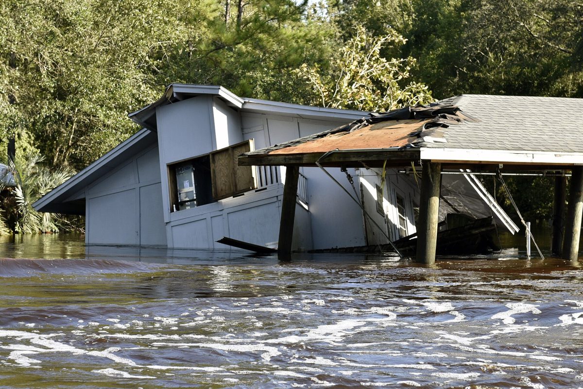
Floodwater surrounds a damaged house along the South Prong of Black Creek in Clay County on Sept. 13, 2017, after Hurricane Irma. Photo: US Fish and Wildlife Service, Southeast Region / Wikimedia Commons (Public domain)
GREEN COVE SPRINGS, Fla. - Clay County property owners who believe the federal government has drawn their land into the wrong flood zone have until Wednesday, Nov. 18, to say so. That is the last day of a 90-day appeal and comment period on the county's proposed Flood Insurance Rate Maps, which opened Aug. 20, according to a Clay County news release issued that day. Once the window closes, the Federal Emergency Management Agency moves toward making the new maps final, and they will replace maps that date to 2014.
The maps matter because they help decide who must buy flood insurance. County officials said in the release that some residents could be newly required to carry a policy, while for others the requirement could end. Most properties will see no change, the county said, but some will be added to or removed from what FEMA calls Special Flood Hazard Areas.
What is changing
FEMA is updating the Flood Insurance Rate Maps for all of Clay County, according to a notice of proposed flood hazard determinations the agency published in the Federal Register on Jan. 21. The notice names Green Cove Springs, Keystone Heights, Orange Park, Penney Farms and the unincorporated area, and it gives the preliminary maps a date of May 29, 2025. The same mapping project also covers Bradford, Duval, Flagler, Putnam and Volusia counties, the notice shows.
Clay County said the updated maps use newer science and data and are more accurate than the 2014 versions. The county and FEMA held an open house on Sept. 12, 2025, at the Clay County Emergency Operations Center in Green Cove Springs, according to a county release from that month. The appeal period is the formal chance for owners to challenge the result before it becomes final.
How to check an address
The county has posted an interactive map at public.claycountygov.com/floodzone where residents can see whether a property is affected. The Town of Orange Park sends its residents to the same tool and says it can be searched by address. The preliminary maps can also be viewed on FEMA's website at hazards.fema.gov/femaportal/prelimdownload, and the maps now in effect are at msc.fema.gov, according to the Federal Register notice.
Paper copies are kept at five community map repositories listed in the federal notice. Each local government has its own, so a Keystone Heights owner does not have to drive to Green Cove Springs to look. The addresses are listed below.


- Unincorporated Clay County: Clay County Economic and Development Services, 477 Houston St., Green Cove Springs
- Green Cove Springs: City Hall, 321 Walnut St.
- Orange Park: Economic and Community Development Department, 2042 Park Ave.
- Keystone Heights: City Hall, 555 S. Lawrence Blvd.
- Penney Farms: Town Hall, 4100 Clark Ave.
What the zones mean
The county's release describes the main flood zones found in Clay County. Zones A, AE and the AE Floodway are the high-risk Special Flood Hazard Areas, where flood insurance is required when a federally backed mortgage is involved. The two versions of Zone X carry lower risk and generally no insurance requirement, the county said.
| Zone | Flood risk | Insurance and permits |
|---|---|---|
| X | Minimal flood hazard | Insurance generally not required; no flood permits needed for development |
| X (shaded) | Moderate; the 500-year floodplain, with a 0.2% chance of flooding each year | Insurance generally not required; no flood permits needed |
| A and AE | The 100-year floodplain, with a 1% chance each year; AE has a measured Base Flood Elevation and A does not | Mortgaged structures require flood insurance; development requires flood permits, plus elevation certificates for new structures or substantial improvements |
| Floodway | The channel of a river, creek or other watercourse and the adjacent land that must be preserved to carry the base flood | Mortgaged structures require flood insurance; new development requires No-Rise Studies, flood permits and elevation certificates |
Appeal or comment: the difference
There are two kinds of feedback, and they are not treated the same. A comment is for incorrect information that does not change the flood hazard data, such as a misspelled road name or a wrong corporate boundary, according to a notice the City of Green Cove Springs posted Aug. 24. An appeal is for concerns backed by technical and scientific data, such as detailed hydraulic or hydrologic studies, the city said.
Clay County put the standard bluntly in its release. "Appeals without data will be denied," the county said. The Federal Register notice adds that a Scientific Resolution Panel of independent experts in hydrology and hydraulics is available to communities when technical data conflict.
Where to send an appeal or comment depends on where the property is. Green Cove Springs said all comments and appeals must go through local officials and suggested that owners discuss an appeal with them before filing. The contacts each government lists are below.
- Unincorporated Clay County: email [email protected]
- Orange Park: email [email protected] or call the Economic and Community Development Department at 904-264-2635
- Green Cove Springs: call City Hall at 904-297-7500
What happens after Nov. 18
The new maps do not take effect when the appeal period ends. Clay County said in 2025 that it anticipated a spring 2027 effective date, and Orange Park's flood zones page says the same, while the Green Cove Springs notice gives a target of summer 2027 and says dates may change pending the appeal review. Until then the current maps govern, and proposed changes may not appear on every mapping tool, Orange Park said.
FEMA describes the last step on its website. The agency sends each community a Letter of Final Determination stating that the new map will take effect in six months, and the community must adopt a compliant floodplain management ordinance by that date to stay in good standing in the National Flood Insurance Program. That letter is the clearest signal owners will get of the date the new zones begin to apply.
Clay County, home to more than 236,000 people according to the county, urged residents and business owners to review the maps and consider how the changes could affect insurance, property protection and emergency planning. Neither the county's releases nor the municipal notices said how many properties would move into or out of the high-risk zones. Owners who are unsure can look up an address on the county map before Wednesday.
Sources: Clay County news release (Aug. 20, 2026); Clay County news release (Sept. 4, 2025); City of Green Cove Springs flood map notice (Aug. 24, 2026); Town of Orange Park flood zones page (accessed Nov. 9, 2026); Federal Register, FEMA Proposed Flood Hazard Determinations, Docket FEMA-B-2578 (Jan. 21, 2026); FEMA Letter of Final Determination page (accessed Nov. 9, 2026); Action News Jax (Aug. 20, 2026)

News organizations may republish this story with credit. See our guidelines.
Know someone who'd want to read this? Email it to a friend.
Know which restaurants passed inspection
Get the week's restaurant inspection results every Sunday, This Weekend in Jacksonville every Thursday and each evening's local stories. Free, and you can unsubscribe anytime.
By signing up you agree to get the Jax Times email newsletter. Unsubscribe anytime with one click.