A 1,009-Pound Great White Shark Named Ernst Pinged off Jacksonville Beach: What OCEARCH's Tracker Shows and What a 'Z-Ping' Means
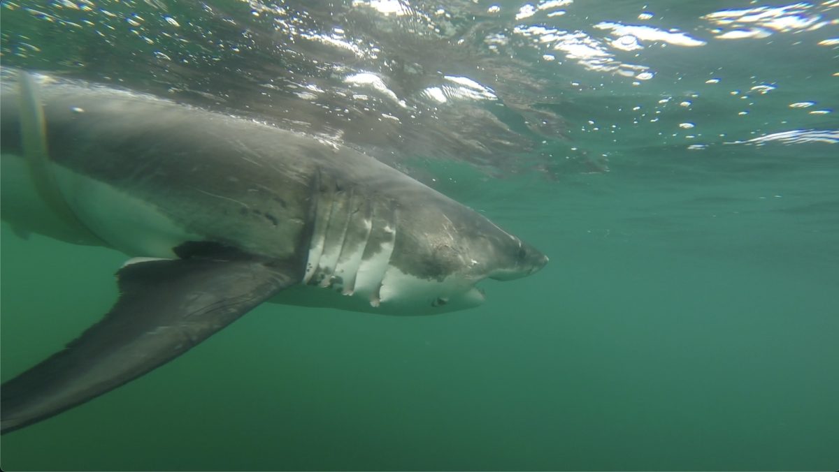
Ernst, the 1,009-pound white shark tracked by OCEARCH, swims after his release. OCEARCH's tracker showed him pinging off Jacksonville Beach this month. Photo: Courtesy of OCEARCH
JACKSONVILLE BEACH, Fla. - A 12-foot, 1,009-pound great white shark named Ernst has been swimming past the First Coast this month, and her satellite tag checked in off Jacksonville Beach before she headed back out to sea. OCEARCH, the nonprofit research group that tagged her, logged a signal off Jacksonville Beach about 6:47 p.m. on Friday, Nov. 13, News4JAX reported. By Tuesday night, Nov. 17, the group's public tracker placed her more than 100 miles offshore, east of the Georgia coast.
Meet Ernst
Ernst is a sub-adult female, meaning she is not yet fully grown, according to OCEARCH. She was tagged on Oct. 4, 2025, in Mahone Bay off Nova Scotia, as part of OCEARCH's research with the Tancook Islands Marine Field Station, which studies how white sharks move and behave in Atlantic Canada. She is named after the William G. Ernst, the ferry that has linked Big and Little Tancook Islands to the mainland since 1982, and the name also honors the ferry's crew, many of whom live on Big Tancook Island, OCEARCH said.
"For more than four decades, this vessel has served as a lifeline for residents," OCEARCH said of the ferry, according to News4JAX. The shark has put plenty of miles behind her since getting her namesake. Her tag start point in Mahone Bay is roughly 1,350 miles from the Jacksonville Beach Pier in a straight line, based on the tracker's coordinates.
What a 'Z-ping' means
The Nov. 13 signal was a "Z-ping," which means OCEARCH could not pin down exactly where she was. "A Z-ping happens when the shark spends only a brief period of time at the surface," OCEARCH said, according to News4JAX, adding that "the signal is sent and received by an Argos satellite but it's not strong enough to determine an accurate location." In other words, the tag reported in, but not long enough for a precise fix.


That limit comes from how the tags work. Walt Golet, an associate professor of marine sciences at the University of Maine, told the Bangor Daily News in July that the tags on large sharks' dorsal fins can reach a satellite only when the fin breaks the surface, because radio signals do not travel through water. The tag maker Wildlife Computers says its SPOT tags send short bursts to the Argos satellite system at the surface, and several transmissions caught in a single satellite pass are used to calculate a location.
What the tracker shows
OCEARCH's public tracker data, checked Nov. 17, also lists a located ping at about 4:52 p.m. on Saturday, Nov. 14, roughly 7 miles east of the Jacksonville Beach Pier. Before that, her last logged position was off the North Carolina coast on Nov. 4, so the tracker shows a gap of about 10 days as she came south. After Saturday she turned back offshore, with pings on Nov. 16 and 17 between about 110 and 135 miles from Jacksonville Beach.
The newest ping on the tracker as of Tuesday night came at 9:04 p.m. Nov. 17, about 110 miles east-northeast of Jacksonville Beach. The dots on the map are not a live feed, and the lines that connect them are not her actual path. Golet put it this way: "Those straight lines are really simplifications of what's likely a complex series of movements."
She has done this before
Ernst's track from last year looks familiar. After her October 2025 tagging, the tracker shows her moving down the East Coast and passing about 90 miles off the Georgia coast on Oct. 31, 2025, then reaching the Florida Keys by mid-November. In January 2026, FOX Weather reported she had traveled from the Keys to the Alabama coast and pinged about four miles off Dauphin Island.
By summer she was back north, and the tracker shows pings as far as the Gulf of St. Lawrence in September 2026. She returned to Nova Scotia waters in early October, about a year after her tagging, then started south again late in the month. That puts her on a similar schedule to last fall's trip.
The pattern fits what researchers have seen across the species. OCEARCH has described the continental shelf off North Carolina, South Carolina, Georgia and Florida's east coast as a winter gathering area for large white sharks, which it calls the Northwest Atlantic Shared Foraging Area. "The body of colder water trapped between the Gulf Stream and the coast is a key feature of this region," Jacksonville University marine scientist Bryan Franks said in a 2019 OCEARCH post.
What it means for the beach
A ping is a data point for scientists, not a beach warning. Ernst's located ping was about 7 miles out, and her later signals were more than 100 miles offshore. White sharks are a federally protected species that fishermen may not keep, and NOAA Fisheries says their numbers in the northwest Atlantic have been increasing since protections began in the 1990s.
Anyone who wants to follow Ernst can find her on OCEARCH's free Global Shark Tracker at ocearch.org, which lists her size, tagging site and every logged ping. Because a new dot appears only when her fin breaks the surface during a satellite pass, days can go by without an update. If she follows last year's route, the next pings could come from farther south along Florida.
Sources: News4JAX (Nov. 17, 2026); OCEARCH tracker (Nov. 17, 2026); Bangor Daily News (July 30, 2026); FOX Weather (Jan. 12, 2026)

News organizations may republish this story with credit. See our guidelines.
Know someone who'd want to read this? Email it to a friend.
Know which restaurants passed inspection
Get the week's restaurant inspection results every Sunday, This Weekend in Jacksonville every Thursday and each evening's local stories. Free, and you can unsubscribe anytime.
By signing up you agree to get the Jax Times email newsletter. Unsubscribe anytime with one click.